
75 Districts of Uttar Pradesh: Map, Population, Administrative Divisions
The historical and cultural heartland and economic center of India can be found in Uttar Pradesh (UP). It stands as both the largest state by total area and the most populous state within the nation. The 75 districts together with one temporary district cover 240,928 square kilometers across Uttar Pradesh which maintains its position as holding the highest number of districts in India. Uttar Pradesh serves as a vibrant community of present and traditional values because it includes Lucknow as its administrative center alongside Varanasi, Agra, Kanpur, Prayagraj (Allahabad), and Ghaziabad, Uttar Pradesh. Up to 75 administrative districts in Uttar Pradesh together with their specific names along with population data and geographical area measurements and established divisions and noteworthy characteristics.
Also Check Our UPPCS Prelims 2024 Qualified Candidates”Join Today Guru’s Ashram IAS for UPSC & PCS EXAM“

Daily Quiz Telegram Channel: Click to Join
Guru’s Ashram IAS Telegram Group: Click to Join
Click To Join Guru’s Ashram IAS Official Whatsapp Channel :- (https://whatsapp.com/channel/0029Va68jla0AgW6JrNUzb44)
Click To Join Our Telegram Group Click Here:- ( https://t.me/gurusaashram )
Click To Join Our Whatsapp Group Click Here:- ( https://chat.whatsapp.com/J4HYp7p6jFa0wOpA644Sur )
Click Here To Call us now!
Enquiry Here, Fill this form & Ask the Questions
Introduction to Uttar Pradesh and Its 75 Districts
The northern Indian state of Uttar Pradesh was established on January 24, 1950 from a total area of 240,928 square kilometers and 200 million inhabitants who make it the most densely populated Indian state. Each district in the state operates under control of a District Magistrate while a Superintendent of Police provides enforcement support to the authority. Eighteen administrative divisions participate in district administration as organizational subdivisions.
On the authority of Mayawati during her time as Chief Minister in 2011 the new districts of Prabuddhanagar (now Shamli), Panchsheel Nagar (now Hapur), and Bhimnagar (now Sambhal) to boost administrative management. Uttar Pradesh demonstrates its readiness to handle an expanding population base through the creation of three new districts.
Lucknow functions as the state capital and cultural center while industrial and religious centers like Kanpur, Varanasi, Agra, Allahabad (Prayagraj) and Ghaziabad maintain importance through their historical background and industrial capacity. Uttar Pradesh stands out as the state with 80 Lok Sabha seats and 403 members in its state legislative assembly which demonstrates clear political power.
How Many Districts Are There in Uttar Pradesh?
The simple inquiry concerns the district count of Uttar Pradesh. The state has 75 established districts as well as one authorized temporary district that includes Maha Kumbh Prayagraj region which the government announced on December 2, 2024 for Kumbh Mela. The total land area of 240,928 square kilometers in Uttar Pradesh makes it the district leader across India. Liberalized authorities control each district of UP which regularly serves populations that exceed 12 lakhs.
The District count of Uttar Pradesh has experienced changes throughout history. During the 2011 administration of Chief Minister Mayawati, Uttar Pradesh acquired three new districts Prabuddhanagar (now Shamli) Panchsheel Nagar (now Hapur) and Bhimnagar (now Sambhal) to improve administrative performance. Aonla district near Bareilly serves as a potential addition to the current district structure. The total count of districts in Uttar Pradesh currently stands at 75 district along with one extra temporary district.
Administrative Divisions of Uttar Pradesh
The districts of Uttar Pradesh maintains 18 administrative divisions, that control the 75 district names of Uttar Pradesh state through designated divisional headquarters. The recorded list contains the divisions of Uttar Pradesh together with their associated district locations shown in detail.
Division | Headquarters | Uttar Pradesh Districts |
| Agra Division | Agra | Agra, Mathura, Mainpuri, Firozabad |
| Aligarh Division | Aligarh | Aligarh, Etah, Hathras, Kasganj |
| Azamgarh Division | Azamgarh | Azamgarh, Ballia, Mau |
| Ayodhya Division | Ayodhya | Ayodhya, Ambedkar Nagar, Barabanki, Sultanpur, Amethi |
| Bareilly Division | Bareilly | Bareilly, Pilibhit, Shahjahanpur, Budaun |
| Basti Division | Basti | Basti, Sant Kabir Nagar, Siddharthnagar |
| Chitrakoot Division | Banda | Banda, Chitrakoot, Hamirpur, Mahoba |
| Devipatan Division | Gonda | Bahraich, Balrampur, Gonda, Shravasti |
| Gorakhpur Division | Gorakhpur | Deoria, Gorakhpur, Kushinagar, Maharajganj |
| Jhansi Division | Jhansi | Jalaun, Jhansi, Lalitpur |
| Kanpur Division | Kanpur | Auraiya, Etawah, Farrukhabad, Kannauj, Kanpur Dehat, Kanpur Nagar |
| Lucknow Division | Lucknow | Hardoi, Lakhimpur Kheri, Lucknow, Rae Bareli, Sitapur, Unnao |
| Meerut Division | Meerut | Baghpat, Bulandshahr, Gautam Buddha Nagar, Ghaziabad, Meerut, Hapur |
| Mirzapur Division | Mirzapur | Mirzapur, Sant Ravidas Nagar (Bhadohi), Sonbhadra |
| Moradabad Division | Moradabad | Bijnor, Amroha, Moradabad, Rampur, Sambhal |
| Prayagraj Division | Prayagraj | Prayagraj, Fatehpur, Kaushambi, Pratapgarh |
| Saharanpur Division | Saharanpur | Muzaffarnagar, Saharanpur, Shamli |
| Varanasi Division | Varanasi | Chandauli, Ghazipur, Jaunpur, Varanasi |
The administrative structure presents a clear breakdown of “districts in UP east” including Varanasi and Gorakhpur and “districts in UP west” including Meerut and Saharanpur for easier regional governance.
Complete List of 75 Districts of Uttar Pradesh
An absolute list of Uttar Pradesh districts presents all 75 district names of Uttar Pradesh alphabetically from UP 75 district names in English.
- Agra
- Aligarh
- Ambedkar Nagar
- Amethi
- Amroha
- Auraiya
- Azamgarh
- Baghpat
- Bahraich
- Ballia
- Balrampur
- Banda
- Barabanki
- Bareilly
- Basti
- Bhadohi (Sant Ravidas Nagar)
- Bijnor
- Budaun
- Bulandshahr
- Chandauli
- Chitrakoot
- Deoria
- Etah
- Etawah
- Ayodhya (Faizabad)
- Farrukhabad
- Fatehpur
- Firozabad
- Gautam Buddha Nagar (Noida)
- Ghaziabad
- Ghazipur
- Gonda
- Gorakhpur
- Hamirpur
- Hapur
- Hardoi
- Hathras
- Jalaun
- Jaunpur
- Jhansi
- Kannauj
- Kanpur Dehat
- Kanpur Nagar
- Kasganj
- Kaushambi
- Kushinagar
- Lakhimpur Kheri
- Lalitpur
- Lucknow
- Maharajganj
- Mahoba
- Mainpuri
- Mathura
- Mau
- Meerut
- Mirzapur
- Moradabad
- Muzaffarnagar
- Pilibhit
- Pratapgarh
- Prayagraj (Allahabad)
- Rae Bareli
- Rampur
- Saharanpur
- Sambhal
- Sant Kabir Nagar
- Shahjahanpur
- Shamli
- Shravasti
- Siddharthnagar
- Sitapur
- Sonbhadra
- Sultanpur
- Unnao
- Varanasi
This list of districts in Uttar Pradesh is comprehensive. For specific subsets like UP 50 district name or UP 30 district name, refer to regional breakdowns or contact official sources.
List of 75 Districts in Uttar Pradesh: Area and Population
Each of Uttar Pradesh’s total 75 districts maintains a unique combination of territorial area and population distribution. The document provides a complete list which includes district names alongside dimensions in square kilometers and population statistics from recent official recordings.
No. | District Name | Area (sq km) | Population |
| 1 | Agra | 4,041 | 4,418,797 |
| 2 | Aligarh | 3,788 | 3,673,889 |
| 3 | Allahabad (Prayagraj) | 5,482 | 5,954,391 |
| 4 | Ambedkar Nagar | 2,350 | 2,397,888 |
| 5 | Amethi | 2,651 | 2,050,133 |
| 6 | Amroha | 2,249 | 1,840,221 |
| 7 | Auraiya | 2,016 | 1,379,545 |
| 8 | Azamgarh | 4,054 | 4,613,913 |
| 9 | Badaun | 4,234 | 3,127,621 |
| 10 | Baghpat | 5,237 | 1,303,048 |
| 11 | Bahraich | 2,981 | 3,487,731 |
| 12 | Ballia | 3,349 | 3,239,774 |
| 13 | Balrampur | 4,408 | 2,148,665 |
| 14 | Banda | 4,402 | 1,799,410 |
| 15 | Barabanki | 4,120 | 3,260,699 |
| 16 | Bareilly | 2,688 | 4,448,359 |
| 17 | Basti | 4,561 | 2,464,464 |
| 18 | Bijnor | 4,262 | 3,682,713 |
| 19 | Bulandshahr | 4,441 | 3,499,171 |
| 20 | Chandauli | 2,541 | 1,952,756 |
| 21 | Chitrakoot | 3,216 | 991,730 |
| 22 | Deoria | 2,540 | 3,100,946 |
| 23 | Etah | 2,431 | 1,774,480 |
| 24 | Etawah | 2,311 | 1,581,810 |
| 25 | Ayodhya (Faizabad) | 2,341 | 2,470,996 |
| 26 | Farrukhabad | 2,181 | 1,885,204 |
| 27 | Fatehpur | 4,152 | 2,632,733 |
| 28 | Firozabad | 2,407 | 2,498,156 |
| 29 | Gautam Buddha Nagar | 720 | 1,648,115 |
| 30 | Ghaziabad | 1,179 | 3,343,334 |
| 31 | Ghazipur | 3,377 | 3,620,268 |
| 32 | Gonda | 4,003 | 3,433,919 |
| 33 | Gorakhpur | 3,321 | 4,440,895 |
| 34 | Hamirpur | 4,021 | 1,104,285 |
| 35 | Hapur | 649 | 1,338,311 |
| 36 | Hardoi | 5,986 | 4,092,845 |
| 37 | Hathras | 1,840 | 1,564,708 |
| 38 | Jalaun | 4,565 | 1,689,974 |
| 39 | Jaunpur | 4,038 | 4,494,204 |
| 40 | Jhansi | 5,024 | 1,998,603 |
| 41 | Kannauj | 2,093 | 1,656,616 |
| 42 | Kanpur Dehat | 3,021 | 1,796,184 |
| 43 | Kanpur Nagar | 3,155 | 4,581,268 |
| 44 | Kasganj | 1,955 | 1,436,719 |
| 45 | Kaushambi | 1,779 | 1,599,596 |
| 46 | Kushinagar | 7,680 | 4,021,243 |
| 47 | Lakhimpur Kheri | 2,905 | 3,564,544 |
| 48 | Lalitpur | 5,039 | 1,221,592 |
| 49 | Lucknow | 2,528 | 4,589,838 |
| 50 | Maharajganj | 2,952 | 2,684,703 |
| 51 | Mahoba | 3,144 | 875,958 |
| 52 | Mainpuri | 2,760 | 1,868,529 |
| 53 | Mathura | 3,340 | 2,547,184 |
| 54 | Mau | 1,713 | 2,205,968 |
| 55 | Meerut | 2,559 | 3,443,689 |
| 56 | Mirzapur | 4,405 | 2,496,970 |
| 57 | Moradabad | 2,233 | 3,126,507 |
| 58 | Muzaffarnagar | 2,742 | 2,869,934 |
| 59 | Pilibhit | 3,686 | 2,031,007 |
| 60 | Pratapgarh | 3,717 | 3,209,141 |
| 61 | Raebareli | 3,937 | 2,903,507 |
| 62 | Rampur | 2,367 | 2,335,819 |
| 63 | Saharanpur | 3,689 | 3,466,382 |
| 64 | Sant Kabir Nagar | 2,390 | 2,199,774 |
| 65 | Sant Ravidas Nagar (Bhadohi) | 1,646 | 1,715,183 |
| 66 | Sambhal | 1,015 | 1,578,213 |
| 67 | Shahjahanpur | 4,388 | 3,006,538 |
| 68 | Shamli | 1,266 | 1,273,578 |
| 69 | Shravasti | 1,640 | 1,117,361 |
| 70 | Siddharthnagar | 2,895 | 2,559,297 |
| 71 | Sitapur | 5,743 | 4,483,992 |
| 72 | Sonbhadra | 6,905 | 1,862,559 |
| 73 | Sultanpur | 2,457 | 2,249,036 |
| 74 | Unnao | 4,558 | 3,108,367 |
| 75 | Varanasi (Kashi) | 1,535 | 3,676,841 |
This table provides a clear snapshot for those searching for UP 75 district name in English, total district in UP, or districts in Uttar Pradesh map with population and area details.
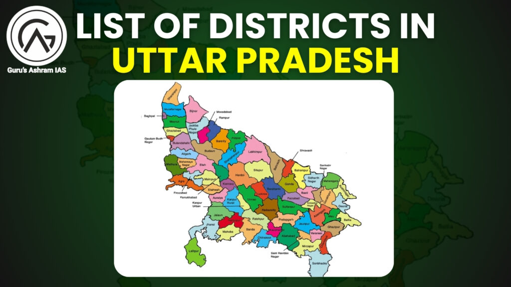
Uttar Pradesh Map with Districts
The Uttar Pradesh district map provides essential geographical representation of all districts found in Uttar Pradesh map. Uttar Pradesh district map shows the complete geographical territory of Uttar Pradesh’s 75 districts while displaying their border linings as well as territorial extents and relationship to specific regions. The districts of UP provide essential information that contains:
- Northern UP: Lakhimpur Kheri along with Bahraich and Shravasti constitute the northern part of UP bordering with the international neighbor Nepal.
- Western UP: The industrial districts of Western Uttar Pradesh are represented by the cities of Meerut and Ghaziabad together with Gautam Buddha Nagar which grow by their proximity to Delhi.
- Eastern UP: The area of Eastern UP includes Varanasi together with Gorakhpur along with Azamgarh as its cultural and spiritual core.
- Central UP: Lucknow and Kanpur anchor administrative and industrial activities.
The official government websites and educational sources provide detailed information about Uttar Pradesh districts through search terms such as “districts in UP west” and “districts in UP east”.
Largest and Smallest Districts in Uttar Pradesh
Largest District in UP by Area
The Uttar Pradesh division of Lakhimpur Kheri occupies 7,680 square kilometers of total district territory in the state. Situated within Lucknow Division this region maintains fame from Dudhwa National Park and its cultivation of sugarcane. Among all districts in Uttar Pradesh the biggest territories belong to Lakhimpur Kheri and Sonbhadra along with Hardoi Prayagraj and Jhansi.
- Lakhimpur Kheri – 7,680 sq km
- Sonbhadra – 6,905 sq km
- Hardoi – 5,986 sq km
- Prayagraj – 5,482 sq km
- Jhansi – 5,024 sq km
Smallest District in UP by Area
The Uttar Pradesh district of Hapur occupies only 649 square kilometers as the smallest administrative region of the state. Hapur represents the smallest among the Uttar Pradesh districts because it belongs to the Meerut Division while operating as an industrial center. The 5/five smallest districts in UP by area consist of:
- Hapur – 649 sq km
- Gautam Buddha Nagar – 720 sq km
- Sambhal – 1,015 sq km
- Shamli – 1,266 sq km
- Baghpat – 1,321 sq km
The region districts of Uttar Pradesh features differences between districts because of its multiple geographical attributes.
Population and Area of UP Districts
Below is a detailed table of the 75 districts of Uttar Pradesh, including their areas and populations (2011 Census, with minor updates):
S.No. | District Name | Area (sq km) | Population |
| 1 | Agra | 4,041 | 4,418,797 |
| 2 | Aligarh | 3,788 | 3,673,889 |
| 3 | Ambedkar Nagar | 2,350 | 2,397,888 |
| 4 | Amethi | 2,329 | 2,050,133 |
| 5 | Amroha | 2,249 | 1,840,221 |
| 6 | Auraiya | 2,016 | 1,379,545 |
| 7 | Azamgarh | 4,054 | 4,613,913 |
| 8 | Baghpat | 1,321 | 1,303,048 |
| 9 | Bahraich | 2,981 | 3,487,731 |
| 10 | Ballia | 3,349 | 3,239,774 |
| 11 | Balrampur | 4,408 | 2,148,665 |
| 12 | Banda | 4,402 | 1,799,410 |
| 13 | Barabanki | 4,120 | 3,260,699 |
| 14 | Bareilly | 2,688 | 4,448,359 |
| 15 | Basti | 4,561 | 2,464,464 |
| 16 | Bhadohi | 1,646 | 1,715,183 |
| 17 | Bijnor | 4,262 | 3,682,713 |
| 18 | Budaun | 4,234 | 3,127,621 |
| 19 | Bulandshahr | 4,441 | 3,499,171 |
| 20 | Chandauli | 2,541 | 1,952,756 |
| 21 | Chitrakoot | 3,216 | 991,730 |
| 22 | Deoria | 2,540 | 3,100,946 |
| 23 | Etah | 2,431 | 1,774,480 |
| 24 | Etawah | 2,311 | 1,581,810 |
| 25 | Ayodhya | 2,555 | 2,470,996 |
| 26 | Farrukhabad | 2,181 | 1,885,204 |
| 27 | Fatehpur | 4,152 | 2,632,733 |
| 28 | Firozabad | 2,407 | 2,498,156 |
| 29 | Gautam Buddha Nagar | 720 | 1,648,115 |
| 30 | Ghaziabad | 1,179 | 3,343,334 |
| 31 | Ghazipur | 3,377 | 3,620,268 |
| 32 | Gonda | 4,003 | 3,433,919 |
| 33 | Gorakhpur | 3,321 | 4,440,895 |
| 34 | Hamirpur | 4,021 | 1,104,285 |
| 35 | Hapur | 649 | 1,338,311 |
| 36 | Hardoi | 5,986 | 4,092,845 |
| 37 | Hathras | 1,840 | 1,564,708 |
| 38 | Jalaun | 4,565 | 1,689,974 |
| 39 | Jaunpur | 4,038 | 4,494,204 |
| 40 | Jhansi | 5,024 | 1,998,603 |
| 41 | Kannauj | 2,093 | 1,656,616 |
| 42 | Kanpur Dehat | 3,021 | 1,796,184 |
| 43 | Kanpur Nagar | 3,155 | 4,581,268 |
| 44 | Kasganj | 1,955 | 1,436,719 |
| 45 | Kaushambi | 1,779 | 1,599,596 |
| 46 | Kushinagar | 2,905 | 4,021,243 |
| 47 | Lakhimpur Kheri | 7,680 | 3,564,544 |
| 48 | Lalitpur | 5,039 | 1,221,592 |
| 49 | Lucknow | 2,528 | 4,589,838 |
| 50 | Maharajganj | 2,952 | 2,684,703 |
| 51 | Mahoba | 3,144 | 875,958 |
| 52 | Mainpuri | 2,760 | 1,868,529 |
| 53 | Mathura | 3,340 | 2,547,184 |
| 54 | Mau | 1,713 | 2,205,968 |
| 55 | Meerut | 2,559 | 3,443,689 |
| 56 | Mirzapur | 4,405 | 2,496,970 |
| 57 | Moradabad | 2,233 | 3,126,507 |
| 58 | Muzaffarnagar | 2,742 | 2,869,934 |
| 59 | Pilibhit | 3,686 | 2,031,007 |
| 60 | Pratapgarh | 3,717 | 3,209,141 |
| 61 | Prayagraj | 5,482 | 5,954,391 |
| 62 | Rae Bareli | 3,937 | 2,903,507 |
| 63 | Rampur | 2,367 | 2,335,819 |
| 64 | Saharanpur | 3,689 | 3,466,382 |
| 65 | Sambhal | 1,015 | 1,578,213 |
| 66 | Sant Kabir Nagar | 2,390 | 2,199,774 |
| 67 | Shahjahanpur | 4,388 | 3,006,538 |
| 68 | Shamli | 1,266 | 1,273,578 |
| 69 | Shravasti | 1,640 | 1,117,361 |
| 70 | Siddharthnagar | 2,895 | 2,559,297 |
| 71 | Sitapur | 5,743 | 4,483,992 |
| 72 | Sonbhadra | 6,905 | 1,862,559 |
| 73 | Sultanpur | 2,457 | 2,249,036 |
| 74 | Unnao | 4,558 | 3,108,367 |
| 75 | Varanasi | 1,535 | 3,676,841 |
This table provides a snapshot of the all districts of Uttar Pradesh, addressing queries like “UP all district name” and “districts of Uttar Pradesh list”.
Importance of Each District in Uttar Pradesh
Each district in UP contributes uniquely to the state’s cultural, economic, and historical fabric. Below is a curated list highlighting the significance of key districts of Uttar Pradesh:
- Agra: Home to the Taj Mahal, a UNESCO World Heritage Site, known for leather goods, textiles, and petha sweets.
- Varanasi: A global spiritual hub, famous for Ganges Ghats, Banarasi sarees, and silk industries.
- Lucknow: The cultural capital, renowned for Awadhi cuisine, Chikankari embroidery, and landmarks like Bara Imambara.
- Kanpur: The “Manchester of the East”, a major industrial and educational hub with IIT Kanpur.
- Prayagraj: Hosts the Kumbh Mela and Triveni Sangam, a key pilgrimage site.
- Mathura: The birthplace of Lord Krishna, famous for Mathura Peda and religious tourism.
- Bhadohi: The “Carpet City of India”, a global leader in hand-knotted carpets.
- Moradabad: Renowned for brass handicrafts and exports.
- Kannauj: The “Perfume Capital”, known for rose water and fragrances.
- Lakhimpur Kheri: The “Sugar Bowl of India”, with Dudhwa National Park hosting rare wildlife.
This diversity underscores the districts in Uttar Pradesh as pivotal to India’s socio-economic landscape.
Importance of The Each 75 Districts of Uttar Pradesh
Each of Uttar Pradesh’s 75 districts plays a vital role in the state’s cultural, economic, and historical fabric. Below is a curated list highlighting the importance of each district, addressing queries like districts of Uttar Pradesh list and all districts of Uttar Pradesh:
S. No. | District | Importance |
| 1 | Agra | Home to the Taj Mahal, famous for leather goods, textiles, and petha sweets. |
| 2 | Aligarh | Known for its lock industry and Aligarh Muslim University. |
| 3 | Allahabad (Prayagraj) | Major pilgrimage site, hosts Kumbh Mela, famous for chikankari embroidery. |
| 4 | Ambedkar Nagar | Named after B.R. Ambedkar, known for agriculture and temples. |
| 5 | Amethi | Parliamentary constituency of Rajiv Gandhi, strong in agriculture. |
| 6 | Amroha | Famous for handcrafted wooden toys and historical sites. |
| 7 | Auraiya | Textile industry hub with historical sites like Pali Temple. |
| 8 | Azamgarh | Rich in literary heritage and pilgrimage sites. |
| 9 | Baghpat | Agricultural hub with historical significance. |
| 10 | Bahraich | Known for wildlife and national parks like Katarniaghat. |
| 11 | Ballia | Cultural heritage and agricultural contributions. |
| 12 | Balrampur | Rich in temples and agricultural production. |
| 13 | Banda | Famous for natural beauty, waterfalls, and weaving. |
| 14 | Barabanki | Historical significance and scenic beauty. |
| 15 | Bareilly | Known for handicrafts and unique cuisine. |
| 16 | Basti | Temples and natural attractions, strong in agriculture. |
| 17 | Bhadohi (Sant Ravidas Nagar) | Renowned for carpet industry and ancient temples. |
| 18 | Bijnor | Natural beauty and agricultural production. |
| 19 | Budaun | Ancient monuments and natural beauty. |
| 20 | Bulandshahr | Blend of cultures with historical monuments. |
| 21 | Chandauli | Industrial center with cultural heritage. |
| 22 | Chitrakoot | Religious significance as a pilgrimage center. |
| 23 | Deoria | Temples and agricultural prominence. |
| 24 | Etah | Known for unique cuisine and cultural heritage. |
| 25 | Etawah | Industrial center with natural beauty. |
| 26 | Ayodhya | Religious hub, significant for Lord Rama’s birthplace. |
| 27 | Farrukhabad | Historical monuments and agricultural contributions. |
| 28 | Fatehpur | Rich in cultural heritage and agriculture. |
| 29 | Firozabad | Famous for glass industry and cultural heritage. |
| 30 | Gautam Buddha Nagar (Noida) | IT and industrial hub with modern infrastructure. |
| 31 | Ghaziabad | Industrial center with strategic location near Delhi. |
| 32 | Ghazipur | Known for mango orchards and folk traditions. |
| 33 | Gonda | Natural beauty and rice production. |
| 34 | Gorakhpur | Educational and commercial hub with historical significance. |
| 35 | Hamirpur | Ancient temples and traditional handicrafts. |
| 36 | Hapur | Industrial center with strategic location. |
| 37 | Hardoi | Eco-tourism and educational centers along the Gomati River. |
| 38 | Hathras | Agricultural hub, famous for hing and Desi Ghee. |
| 39 | Jalaun | Rich in mineral resources and handicrafts. |
| 40 | Jaunpur | Emerging industries and tourist attractions. |
| 41 | Jhansi | Historical significance as a railway junction. |
| 42 | Kannauj | Perfume capital, famous for rose water and festivals. |
| 43 | Kanpur Dehat | Agricultural economy with dairy farming. |
| 44 | Kanpur Nagar | Major industrial city with educational institutions. |
| 45 | Kasganj | Known for buffalo milk ghee and export industry. |
| 46 | Kaushambi | Historical and religious center. |
| 47 | Lakhimpur Kheri | Sugar production and wildlife, home to Dudhwa National Park. |
| 48 | Kushinagar | Major Buddhist pilgrimage site with handloom industry. |
| 49 | Lalitpur | Ceramic and terracotta handicrafts. |
| 50 | Lucknow | Cultural hub famous for architecture, cuisine, and education. |
| 51 | Maharajganj | Protected forests and wildlife sanctuaries. |
| 52 | Mahoba | Sun temple and mineral resources. |
| 53 | Mainpuri | Cotton ginning and oilseed milling industries. |
| 54 | Mathura | Birthplace of Lord Krishna, famous for Mathura Peda. |
| 55 | Mau | Handloom industry, known for Banarasi sarees. |
| 56 | Mirzapur | Brass industry and carpets. |
| 57 | Meerut | Industrial hub with historical significance. |
| 58 | Moradabad | Brass industry and export hub. |
| 59 | Muzaffarnagar | Sugar industry and Haiderpur wetland. |
| 60 | Pilibhit | Home to Pilibhit Tiger Reserve and mining. |
| 61 | Pratapgarh | Agrarian district with Kisan Devta Mandir. |
| 62 | Raebareli | Industrial hub with NTPC and Modern Coach Factory. |
| 63 | Rampur | Famous for Rampur knife and poetry. |
| 64 | Saharanpur | Wood carving and cottage industries. |
| 65 | Sambhal | Brass industry and cottage crafts. |
| 66 | Sant Kabir Nagar | Cultural heritage, Samadhi sthal of Sant Kabir. |
| 67 | Shahjahanpur | Known for mangoes and educational institutions. |
| 68 | Shamli | Sugarcane and jaggery production. |
| 69 | Shravasti | Ancient city ruins and Jain temples. |
| 70 | Siddharthnagar | Wildlife and cultural heritage. |
| 71 | Sitapur | Traditional crafts and mango production. |
| 72 | Sonbhadra | Industrial hub with Obra and Rihand Dams. |
| 73 | Sultanpur | Historical significance with Dudhnath Baba Ji Maharaj Temple. |
| 74 | Unnao | Leather industries and archaeological sites. |
| 75 | Varanasi | Spiritual hub, famous for Banarasi sarees and Ganges ghats. |
This table addresses queries like districts in UP east, districts in UP west, and aspirational districts in UP, showcasing the multifaceted contributions of each district.
New and Aspirational Districts in Uttar Pradesh
New Districts in Uttar Pradesh
The new districts of Uttar Pradesh reflect adaptive governance:
- Prabuddhanagar (Shamli), Panchsheel Nagar (Hapur), Bhimnagar (Sambhal) (2011): Created for administrative efficiency.
- Maha Kumbh area of Prayagraj (2024): A temporary district for the Kumbh Mela.
- Proposed Aonla District: Under consideration in Bareilly.
These new districts in Uttar Pradesh address queries like “new districts of Uttar Pradesh”.
Aspirational Districts in Uttar Pradesh
How many aspirational districts in UP? Eight districts in UP are part of India’s Aspirational Districts Programme, focusing on socio-economic development:
- Bahraich
- Balrampur
- Chandauli
- Chitrakoot
- Fatehpur
- Shravasti
- Siddharthnagar
- Sonbhadra
These aspirational districts in UP target improvements in education, health, and infrastructure, answering “how many aspirational districts in UP?”
Uttar Pradesh District Map
View the Uttar Pradesh districts’ geographical spread on the Uttar Pradesh map with districts. The district boundaries and dimensions showcase the districts locating from Lakhimpur Kheri in the north to Sonbhadra in the south. You will find this tool necessary whenever you need information about districts in Uttar Pradesh map or the map of districts of Uttar Pradesh, or districts of UP map.
New Districts in Uttar Pradesh
Uttar Pradesh made a firm decision to enhance responsible governance by creating Prabuddhanagar (Shamli) Panchsheel Nagar (Hapur) and Bhimnagar (Sambhal) in 2011. The Uttar Pradesh administration introduced these new districts to solve administrative needs and establish proper advocacy for the local communities. The administrative developments facing new districts of Uttar Pradesh become more visible due to these recent changes.
Aspirational Districts in Uttar Pradesh
The Government of India through its Aspirational Districts Programme sets its sight on districts that require specific developmental attention. Bahraich and Balrampur in addition to Chandauli and Chitrakoot together with Fatehpur and Shravasti and Siddharthnagar and Sonbhadra are the 8 districts identified in Uttar Pradesh. The development programs target these specific districts to enhance their health services and education and infrastructure which answers the question of how many aspirational districts in UP exist.
Why Uttar Pradesh’s Districts Matter
As parts of Uttar Pradesh exceed their administrative status they embody the fundamental strength that defines the state as a whole. The diversified landscape of Uttar Pradesh consists of Agra’s worldwide tourism hub, Noida’s IT control, Varanasi’s religious heritage alongside Lakhimpur Kheri‘s natural wealth which together establish Uttar Pradesh as India’s most prominent cultural-historical economic landscape. The guide delivers an elaborate human-generated resource that enables understanding of Uttar Pradesh’s diverse districts while covering UP 75 district name and districts in Uttar Pradesh and the number of districts in UP.
Detailed information about India’s biggest state can be found through viewing either the Uttar Pradesh district list or districts of UP map or individual district profiles.
Conclusion
Uttar Pradesh, with its 75 districts and one temporary district, is a cornerstone of India’s cultural, political, and economic landscape. This guide has comprehensively covered the Uttar Pradesh district list, answering how many districts are there in Uttar Pradesh, detailing the districts in Uttar Pradesh map, and highlighting the total number of districts in Uttar Pradesh. From UP 75 district name to districts in UP east and west, this article is your go-to resource. Optimized for keywords like “districts in Uttar Pradesh,” “UP all district name,” and “new districts of Uttar Pradesh”.
FAQs of Districts of Uttar Pradesh
How Many Districts Are in Uttar Pradesh?
Uttar Pradesh has 75 districts, making it the state with the highest number of districts in India. These districts are organized into 18 administrative divisions for efficient governance. For those searching how many districts are there in Uttar Pradesh, total district in UP, or number of districts in Uttar Pradesh, the answer is consistently 75 districts.
Which State Has 75 Districts?
Uttar Pradesh is the only state in India with 75 districts. This distinction underscores its vast geographical and demographic scale, covering 240,928 square kilometers and a population exceeding 200 million. Queries like districts in Uttar Pradesh or total number of districts in Uttar Pradesh often point to this unique feature.
Is There 75 or 76 Districts in UP?
There are 75 districts in Uttar Pradesh, and no 76th district exists as of April 19, 2025. The state’s district count was last updated in 2011 with the addition of Shamli (Prabuddhanagar), Hapur (Panchsheel Nagar), and Sambhal (Bhimnagar). For clarity on districts of UP, UP 75 district name, or how many districts of UP, the total remains 75.
Which Is the 75th District of UP?
The 75th district of Uttar Pradesh, based on alphabetical listing, is Varanasi (Kashi). Known for its spiritual significance, Varanasi is a global pilgrimage center with its Ganges ghats and Banarasi saree industry. This answers queries like 75 district name of Uttar Pradesh and UP 75 district name in English.
Which Is the 76th District of UP?
There is no 76th district in Uttar Pradesh. The state currently has 75 districts, addressing misconceptions in searches like is there 75 or 76 district in UP or districts in Uttar Pradesh.
Which District Is the Largest in UP?
Lakhimpur Kheri is the largest district in Uttar Pradesh by area, spanning 7,680 square kilometers. Located in the Lucknow Division and bordering Nepal, it is home to Dudhwa National Park, a biodiversity hotspot. This answers queries like which district is largest in UP, largest district list, and districts of Uttar Pradesh.
Which Is the Smallest District in UP?
Bhadohi (Sant Ravidas Nagar) is the smallest district in Uttar Pradesh by area, covering 1,646 square kilometers. Known for its carpet industry, Bhadohi is a cultural hub near Varanasi. Relevant for searches like districts in UP and UP all district name.
What Is the Old Name of Uttar Pradesh?
The old name of Uttar Pradesh was the United Provinces, established during British rule. It was renamed Uttar Pradesh on January 24, 1950, post-independence. This addresses queries like old name of Uttar Pradesh and districts of UP.
Which District of UP Touches 4 States?
Sonbhadra, located in southeastern Uttar Pradesh, is the only district that touches four states: Madhya Pradesh, Chhattisgarh, Jharkhand, and Bihar. Spanning 6,905 square kilometers, it is a key industrial hub with the Obra and Rihand Dams. This answers which district of UP touches 4 states and districts in UP east.
Which Is the New District of UP?
The newest districts in Uttar Pradesh are Shamli, Hapur, and Sambhal, created in 2011 under then-Chief Minister Mayawati. Previously known as Prabuddhanagar, Panchsheel Nagar, and Bhimnagar, respectively, these districts were added to improve administrative efficiency. Relevant for new districts in Uttar Pradesh and new districts of Uttar Pradesh.
Which Is the 72nd District of Uttar Pradesh?
Based on alphabetical order, the 72nd district is Sonbhadra. Known for its industrial significance and natural resources, it is part of the Mirzapur Division. This addresses which is the 72nd district of Uttar Pradesh and 75 district name of Uttar Pradesh.
Which District Is UP 70?
The 70th district in alphabetical order is Siddharthnagar, part of the Basti Division. It is known for its cultural heritage and wildlife. This answers which district is UP 70 and districts in Uttar Pradesh.
Which District Name Is 50 in UP?
The 50th district in alphabetical order is Maharajganj, located in the Gorakhpur Division. It is notable for its protected forests and agricultural contributions. Relevant for UP 50 district name and districts of Uttar Pradesh list.
What Is the City Name of UP 1?
The first district alphabetically is Agra, with Agra city as its headquarters. Famous for the Taj Mahal, Agra is a global tourism hub. This answers what is the city name of UP 1 and UP all district name and number.
UP 2 District Name
The second district alphabetically is Aligarh, with Aligarh city as its headquarters. Known for its lock industry and Aligarh Muslim University, it addresses UP 2 district name and UP 75 district name in English.
Which City Is UP 75?
The 75th district alphabetically is Varanasi, with Varanasi city as its headquarters. A spiritual and cultural center, it is famous for its ghats and silk industry. This answers which city is UP 75 and 75 district name of Uttar Pradesh.
How Many Zones Are There in Uttar Pradesh?
Uttar Pradesh is divided into 18 administrative divisions, often referred to as zones, each with its own headquarters. These divisions manage the 75 districts for streamlined governance. Relevant for how many zones are there in Uttar Pradesh and districts in Uttar Pradesh.
UP West District List
The western districts of Uttar Pradesh fall under divisions like Meerut, Saharanpur, and Agra. Key districts include:
- Agra
- Aligarh
- Baghpat
- Bulandshahr
- Firozabad
- Gautam Buddha Nagar (Noida)
- Ghaziabad
- Hapur
- Hathras
- Mathura
- Meerut
- Muzaffarnagar
- Saharanpur
- Shamli
These districts are known for industrial, agricultural, and cultural significance. This addresses districts in UP west and districts in Uttar Pradesh map.
UP East District List
The eastern districts of Uttar Pradesh are part of divisions like Varanasi, Azamgarh, and Gorakhpur. Key districts include:
- Azamgarh
- Ballia
- Chandauli
- Deoria
- Ghazipur
- Gorakhpur
- Jaunpur
- Kushinagar
- Maharajganj
- Mau
- Varanasi
These districts are rich in cultural heritage and agriculture. Relevant for districts in UP east and districts of UP.
How Many Aspirational Districts in UP?
Uttar Pradesh has 8 aspirational districts under the Government of India’s Aspirational Districts Programme:
- Bahraich
- Balrampur
- Chandauli
- Chitrakoot
- Fatehpur
- Shravasti
- Siddharthnagar
- Sonbhadra
These districts receive focused development in health, education, and infrastructure. This answers how many aspirational districts in UP and aspirational districts in UP.
75 District Name of Uttar Pradesh
Below is the complete list of 75 districts in Uttar Pradesh, addressing UP 1 to 75 district name, UP 75 district name in English, and 75 district name of Uttar Pradesh:
- Agra
- Aligarh
- Allahabad (Prayagraj)
- Ambedkar Nagar
- Amethi
- Amroha
- Auraiya
- Azamgarh
- Badaun
- Baghpat
- Bahraich
- Ballia
- Balrampur
- Banda
- Barabanki
- Bareilly
- Basti
- Bijnor
- Bulandshahr
- Chandauli
- Chitrakoot
- Deoria
- Etah
- Etawah
- Ayodhya (Faizabad)
- Farrukhabad
- Fatehpur
- Firozabad
- Gautam Buddha Nagar
- Ghaziabad
- Ghazipur
- Gonda
- Gorakhpur
- Hamirpur
- Hapur
- Hardoi
- Hathras
- Jalaun
- Jaunpur
- Jhansi
- Kannauj
- Kanpur Dehat
- Kanpur Nagar
- Kasganj
- Kaushambi
- Kushinagar
- Lakhimpur Kheri
- Lalitpur
- Lucknow
- Maharajganj
- Mahoba
- Mainpuri
- Mathura
- Mau
- Meerut
- Mirzapur
- Moradabad
- Muzaffarnagar
- Pilibhit
- Pratapgarh
- Raebareli
- Rampur
- Saharanpur
- Sant Kabir Nagar
- Sant Ravidas Nagar (Bhadohi)
- Sambhal
- Shahjahanpur
- Shamli
- Shravasti
- Siddharthnagar
- Sitapur
- Sonbhadra
- Sultanpur
- Unnao
- Varanasi (Kashi)
This list is ideal for Uttar Pradesh district list, districts of Uttar Pradesh, and UP all district name and number.
UP 50 District Name
The first 50 districts alphabetically are:
- Agra
- Aligarh
- Allahabad (Prayagraj)
- Ambedkar Nagar
- Amethi
- Amroha
- Auraiya
- Azamgarh
- Badaun
- Baghpat
- Bahraich
- Ballia
- Balrampur
- Banda
- Barabanki
- Bareilly
- Basti
- Bijnor
- Bulandshahr
- Chandauli
- Chitrakoot
- Deoria
- Etah
- Etawah
- Ayodhya (Faizabad)
- Farrukhabad
- Fatehpur
- Firozabad
- Gautam Buddha Nagar
- Ghaziabad
- Ghazipur
- Gonda
- Gorakhpur
- Hamirpur
- Hapur
- Hardoi
- Hathras
- Jalaun
- Jaunpur
- Jhansi
- Kannauj
- Kanpur Dehat
- Kanpur Nagar
- Kasganj
- Kaushambi
- Kushinagar
- Lakhimpur Kheri
- Lalitpur
- Lucknow
- Maharajganj
This addresses UP 50 district name and districts in Uttar Pradesh.
UP 30 District Name
The first 30 districts alphabetically are:
- Agra
- Aligarh
- Allahabad (Prayagraj)
- Ambedkar Nagar
- Amethi
- Amroha
- Auraiya
- Azamgarh
- Badaun
- Baghpat
- Bahraich
- Ballia
- Balrampur
- Banda
- Barabanki
- Bareilly
- Basti
- Bijnor
- Bulandshahr
- Chandauli
- Chitrakoot
- Deoria
- Etah
- Etawah
- Ayodhya (Faizabad)
- Farrukhabad
- Fatehpur
- Firozabad
- Gautam Buddha Nagar
- Ghaziabad
This answers UP 30 district name and list of districts in Uttar Pradesh.
75 District Name of Uttar Pradesh PDF
For a downloadable 75 district name of Uttar Pradesh PDF, you can find resources on official Uttar Pradesh government websites or educational portals. These PDFs typically include the Uttar Pradesh district list, districts in Uttar Pradesh map, and details like area and population. Search for 75 district Name of Uttar Pradesh PDF on government sites for authentic documents.
Uttar Pradesh Map with District
The Uttar Pradesh map with districts visually represents the 75 districts, showing their geographical boundaries and locations. From Lakhimpur Kheri in the north to Sonbhadra in the south, the map is crucial for understanding districts in Uttar Pradesh map, districts of UP map, and map of districts of Uttar Pradesh. You can find detailed maps on government websites or educational resources.
Also, Check Related Aricles:
List of Indian States and Their Districts
India, a vast and diverse country, consists of 28 states. Each state is administratively divided into districts, which are essential for governance, administration, and local development. Below is the updated list of all states along with the link/mention to their respective districts.
S. No. | Name of the State |
1 | Andhra Pradesh – List of Districts in Andhra Pradesh |
2 | Arunachal Pradesh – List of Districts in Arunachal Pradesh |
3 | Assam – List of Districts in Assam |
4 | Bihar – List of Districts in Bihar |
5 | Chhattisgarh – List of Districts in Chhattisgarh |
6 | Goa – List of Districts in Goa |
7 | Gujarat – List of Districts in Gujarat |
8 | Haryana – List of Districts in Haryana |
9 | Himachal Pradesh – List of Districts in Himachal Pradesh |
10 | Jharkhand – List of Districts in Jharkhand |
11 | Karnataka – List of Districts in Karnataka |
12 | Kerala – List of Districts in Kerala |
13 | Madhya Pradesh – List of Districts in Madhya Pradesh |
14 | Maharashtra – List of Districts in Maharashtra |
15 | Manipur – List of Districts in Manipur |
16 | Meghalaya – List of Districts in Meghalaya |
17 | Mizoram – List of Districts in Mizoram |
18 | Nagaland – List of Districts in Nagaland |
19 | Odisha – List of Districts in Odisha |
20 | Punjab – List of Districts in Punjab |
21 | Rajasthan – List of Districts in Rajasthan |
22 | Sikkim – List of Districts in Sikkim |
23 | Tamil Nadu – List of Districts in Tamil Nadu |
24 | Telangana – List of Districts in Telangana |
25 | Tripura – List of Districts in Tripura |
26 | Uttar Pradesh – List of Districts in Uttar Pradesh |
27 | Uttarakhand – List of Districts in Uttarakhand |
28 | West Bengal – List of Districts in West Bengal |
Related Article:
24 UPSC Civil Services Post
All UPSC Posts and Salary | 24 Types of Civil Services Under UPSC
UPSC Calendar
UPSC Calendar 2025 OUT, Check CSE Exam Date, Download PDF
UPSC Syllabus
UPSC Syllabus 2025: Prelims, Mains & Interview – Download PDF
IAS Salary
UPSC IAS Salary In India 2025, Perks & Benefits
IPS Salary
IPS Officer’s Per Month Salary, Perks & Allowances, Grade Pay in 2025
IRS Salary
IRS Officer Salary, Training, Perks & Promotion
IFoS Salary
IFoS Salary in India, Ranks & Perks
SDM Salary
State-Wise SDM Salary in India 2025
PCS Salary
PCS Salary in India 2025
